Double Typhoons Approaching: Stay on High Alert for Fujiwhara Effect
Two typhoons (No. 7 & 8) are approaching Japan simultaneously. Learn about the Fujiwhara effect, scientific mechanisms, historical disasters, current pressure data, and critical safety actions.
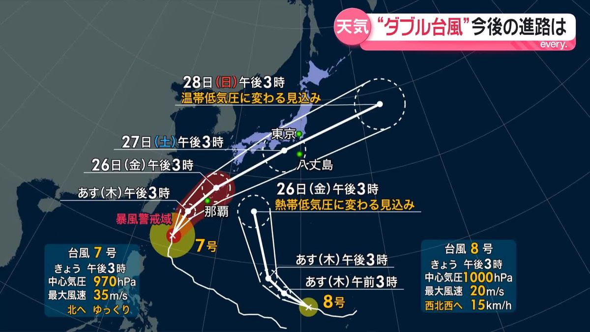
Currently, Typhoon No. 7 (Mekkhala) and Typhoon No. 8 (Higos) are active simultaneously in the waters south of Japan and near the Mariana Islands, both moving northward toward the Japanese archipelago. According to the latest observations from the Japan Meteorological Agency, these two typhoons are expected to approach within 1,000 kilometers of each other in the coming days. This proximity raises severe concerns about a mutual interference phenomenon known as the "Fujiwhara Effect."
When two typhoons get close, their paths become highly unpredictable—often resulting in deceleration, stagnation, or sudden, sharp route changes. This article provides a comprehensive and reliable guide to the scientific mechanism of the Fujiwhara effect, current pressure and wind speed data, historical disaster precedents, and concrete evacuation plans to protect lives.
Typhoon Interaction and the Mechanism of the "Fujiwhara Effect"
The "Fujiwhara Effect" refers to a phenomenon where two or more typhoons approach within a relatively close distance (generally within 1,000 km) and interact, resulting in unusual paths. This theory was first formulated in 1921 by Dr. Sakuhei Fujiwhara, then Director-General of the Central Meteorological Observatory (now the Japan Meteorological Agency), based on water tank experiments and real-world observations. It is now recognized globally as a standard meteorological term.
Depending on the relative strength and positioning of the typhoons, the Fujiwhara effect is classified into six main patterns:
1. **Merging (相寄り型)**: The weaker typhoon weakens and gets absorbed into the circulation of the stronger one, eventually merging into a single system.
2. **Directional/Orbiting (指向型)**: When one typhoon is dominant, the weaker one orbits around the stronger one in a counterclockwise direction.
3. **Following (追従型)**: A newer typhoon follows the path of an older one, leading to consecutive storms hit the same region along the same route.
4. **Time-Waiting (時間待ち型)**: The eastern typhoon blocks the path of the western one, causing it to stall until the eastern storm moves north and clears the way.
5. **Accompanying (同行型)**: The two typhoons travel side-by-side in parallel, leading to an extremely wide impact area.
6. **Separating (離反型)**: The eastern typhoon accelerates northeast while the western one is pushed west, decelerating or moving south as they repel each other.
Typhoons No. 7 and No. 8 are currently projected to exhibit a complex path close to the Orbiting or Time-Waiting pattern due to the influence of the Pacific High and jet streams. Consequently, weather simulation models show high variance in path prediction.
Current Typhoon Intensity and Barometric Pressure Comparison
Below is a summary of the latest observations for Typhoon No. 7 (Mekkhala) and Typhoon No. 8 (Higos). Typhoon No. 7 is currently moving north toward Okinawa, maintaining its strength, while Typhoon No. 8 is moving west-northwest near the Mariana Islands.
| Observation Item | Typhoon No. 7 (Mekkhala) | Typhoon No. 8 (Higos) |
|---|---|---|
| Central Pressure | 960 hPa | 990 hPa |
| Max Wind Speed | 35 m/s (Strong) | 20 m/s |
| Max Instantaneous Gust | 50 m/s | 30 m/s |
| Current Location | Moving north south of Okinawa | Mariana Islands Region |
| Direction & Speed | North at 15 km/h | West-Northwest at 20 km/h |
| Storm Alert Area | 130 km radius | None |
*The above data represents real-time observation values and may change rapidly depending on sea surface temperatures and upper-level winds.
Historical Disasters of Double/Multiple Typhoons
There have been numerous cases where multiple simultaneous typhoons brought severe damage to Japan. Two historical precedents stand out:
1. 2013: Interaction of Typhoon No. 27 (920 hPa) and No. 28 (905 hPa)
In late October 2013, two powerful typhoons traveled near Japan's southern coast almost simultaneously, showcasing a classic Fujiwhara interaction. The leading storm, No. 27, slowed down significantly, while No. 28 pushed northward behind it. This interaction caused the autumn rain front to stall over the Japanese mainland, triggering record-breaking heavy rain and flooding across the nation, particularly affecting areas in Izu Oshima that were already devastated by Typhoon No. 26.
2. 2016: The "Reverse and Erratic" Path of Typhoon No. 10 (Lionrock)
Typhoon No. 10 in August 2016 is remembered as one of the most erratic storms in history. It initially moved south from near Hachijojima toward Minamidaitojima. However, due to interaction (Fujiwhara effect) with Typhoons No. 9 and No. 11, it suddenly performed a U-turn and headed northeast. It made landfall near Ofunato City, Iwate Prefecture—becoming the first typhoon in recorded history to make landfall on the Pacific side of the Tohoku region, causing massive flooding and casualties.
These historical events show that the true danger of double typhoons lies not just in their wind speeds, but in their **unpredictable paths and significant slowdowns**.
The True Danger of Double Typhoons: Extended Rainfall and Frontal Triggers
Many believe the biggest risk of two typhoons is merging into one giant storm. In reality, the stagnation of weather patterns is far more hazardous.
・Prolonged Rain Due to Stagnation
When a typhoon's speed drops to around 10 km/h (comparable to a bicycle), torrential rain clouds hover over the same region for an extended period. This leads to cumulative rainfall exceeding monthly averages in a single day, triggering large-scale river floods and landslides.
・Moisture Pipeline Formation
When the counterclockwise wind from the eastern typhoon merges with the updraft of the western one, a massive stream of warm, moist tropical air is funneled directly into the Japanese archipelago. When this hits the autumn front or mountain ranges, it triggers persistent linear rainbands (senjo-kousuibai), causing localized deluge hundreds of kilometers away from the actual storms.
Actionable Disaster Prevention and Evacuation Guide
During a double typhoon event, forecast path maps can change drastically every few hours. Therefore, early, proactive evacuation based on the worst-case scenario is critical.
【Double Typhoon Disaster Prevention Action Plan】
1. **Increase Information Updates**: Check the updated 5-day typhoon forecast every 3 hours, as paths can change abruptly.
2. **Early Evacuation**: For households with elderly or vulnerable members, complete evacuation to a safe location before the storm enters the warning zone (equivalent to Alert Level 3).
3. **Prepare for Utility Outages**: Secure at least 3 days of food and water, and ensure mobile batteries are fully charged to prepare for potential power grid and water line failures.
4. **Recheck Hazard Maps**: If you live in an area prone to flooding or landslides, plan a horizontal evacuation out of the danger zone rather than just vertical evacuation within your home.
Do not let the calm before the storm mislead you. Secure loose items and clean gutters during daylight hours before wind and rain intensify, and avoid any non-essential travel while the typhoons pass.
【Sources】
1. Japan Meteorological Agency: "Information on Typhoons & Historical Disaster Data"
2. Cabinet Office: "Disaster Prevention Information Page"
3. Japan Weather Association: "tenki.jp Typhoon Information and Fujiwhara Effect Guide"